In the world of navigation and aviation, Garmin is a well-established name known for its innovative solutions and cutting-edge technology.
One of their notable offerings is Garmin Digital Charts, a comprehensive system designed to provide pilots and mariners with accurate and up-to-date navigational information.
In this article, we will explore what Garmin Digital Charts are, their features, and their significance in the field of navigation.

Understanding Garmin Digital Charts:
Garmin Digital Charts are electronic navigation charts that replace traditional paper charts. These charts are stored in digital format and can be accessed through compatible Garmin devices such as aviation or marine GPS units. They offer a wealth of information, including topographical data, water depths, navigational aids, airports, airspace boundaries, and much more.
Types of Garmin Digital Charts:
Garmin offers different types of digital charts tailored to specific applications. The two main categories are:
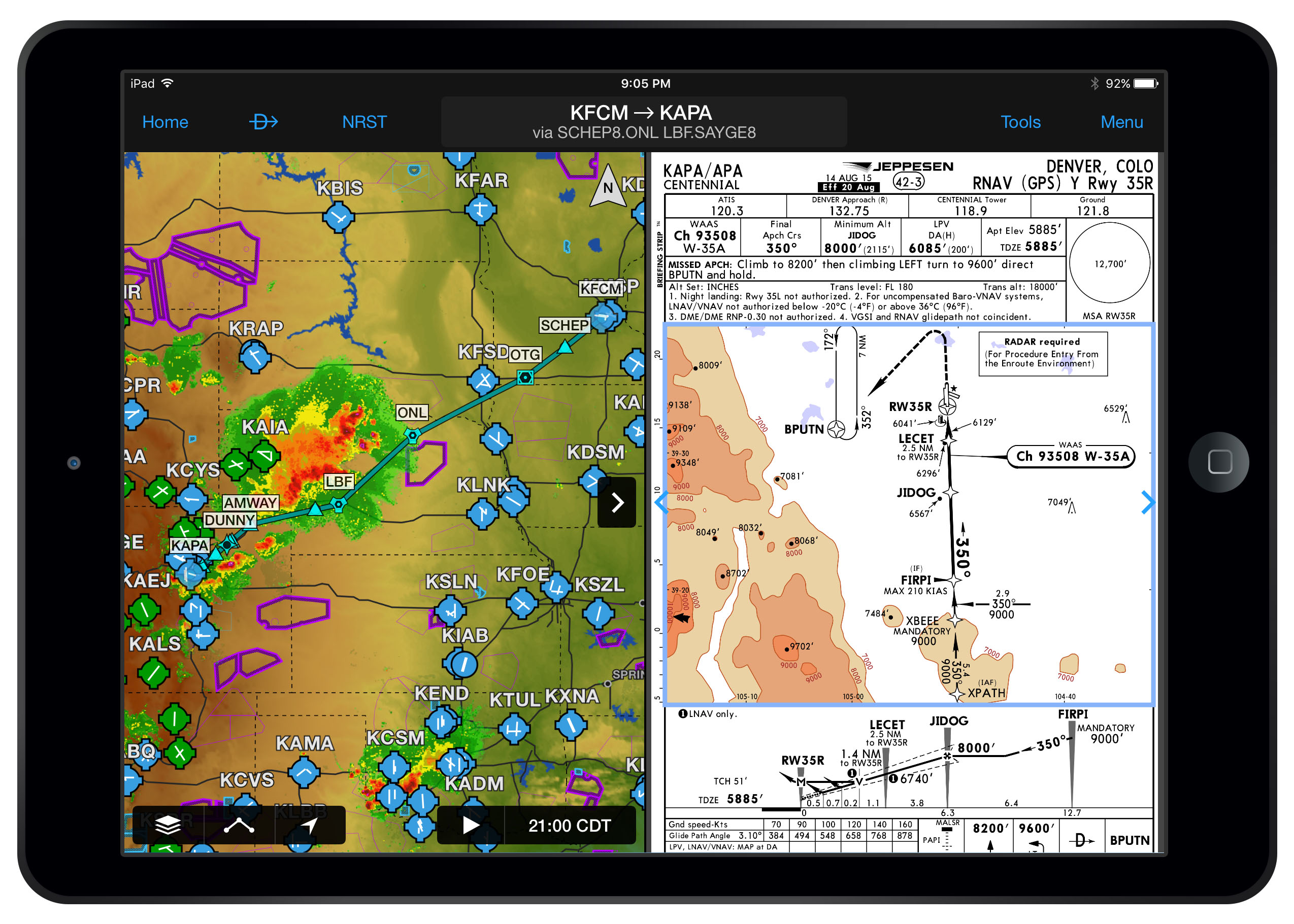
Garmin Aviation Charts: These charts cater to the aviation industry and are essential tools for pilots. They include aeronautical navigation data, airport information, airspace restrictions, approach charts, and instrument procedures. Garmin offers several aviation chart options, such as Garmin FliteCharts, Jeppesen NavData, and Garmin ChartView.
Garmin Marine Charts: Designed for boaters and mariners, Garmin Marine Charts provide detailed coastal and inland waterway maps. They offer information about water depths, navigation aids, harbor details, tides, currents, and more. These charts ensure safe and efficient navigation in marine environments.
Features and Benefits:
Garmin Digital Charts come with a range of features that enhance safety and convenience for pilots and mariners alike:
Comprehensive Coverage: Garmin Digital Charts cover extensive areas, including major airports, water bodies, and coastal regions worldwide. The charts are regularly updated to reflect changes in infrastructure, airspace, and waterways.
Interactive Capabilities: Garmin Digital Charts enable users to interact with the maps, allowing for seamless zooming, panning, and searching for specific locations. This functionality facilitates easy route planning and situational awareness.
Integration with Garmin Devices: These charts are designed to integrate seamlessly with Garmin aviation and marine devices. Pilots and mariners can access the charts directly on compatible Garmin GPS units, multi-function displays, or mobile applications.
Weather Overlay: Some Garmin Digital Charts also offer weather overlay features, allowing users to view real-time weather conditions, including radar imagery, lightning strikes, and storm tracks. This integration assists in making informed decisions while planning flights or navigating through challenging weather conditions.
Customization Options: Garmin Digital Charts provide customization options, allowing users to tailor the displayed information based on their specific needs and preferences. This flexibility ensures that pilots and mariners can focus on the most relevant data for their respective journeys.
How to Access Garmin Digital Charts:
To access Garmin Digital Charts, users typically need compatible Garmin devices and subscriptions for the desired chart service. These subscriptions are available for purchase through Garmin’s official website or authorized retailers. Once subscribed, users can download the necessary chart data and transfer it to their Garmin devices using Garmin’s proprietary software.
Conclusion:
Garmin Digital Charts have revolutionized navigation in both aviation and marine industries. With their accurate and up-to-date information, interactive features, and seamless integration with Garmin devices, these charts provide pilots and mariners with the tools they need for safe and efficient navigation.
Whether it’s planning a flight or charting a course on the open sea, Garmin Digital Charts have become an indispensable resource, empowering users with comprehensive navigational data at their fingertips.